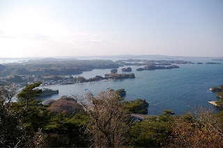
(from Wikipedia): Matsushima (松島) is a group of islands in Miyagi Prefecture, Japan. There are some 260 tiny islands (shima) covered in pines (matsu) – hence the name – and is ranked as one of the Three Views of Japan. The Three Views of Japan (日本三景 Nihon Sankei) is the canonical list of Japan's most famous sights, somewhat akin to the Seven Wonders of the Ancient World. The list is usually attributed to scholar Hayashi Razan, who first listed them in 1643.
The news is not too bad for Matsushima Bay, although it's been hard to find any news. The bay is at the north end of the Sendai plain so somewhat protected, and it's on a terrace [see photos]. So compared to towns farther north, they are relatively ok. Yesterday I found the website for the town of Matsushima up and reporting to its citizens what was working and what was not, where they could get help, and so on. The 6 deaths reported were sick people who were already in the hospital. In a sign of normalcy, garbage pickup is proceeding. . The website is in Japanese, but I could get the gist of it from my Google Chrome auto-translator. http://www.town.matsushima.miyagi.jp/
Above: view of Matsushima Bay. Photographer: Kumamishi [via wiki commons]
So it's time for me to start my tour of the towns we visited last April on a trip to see how these towns had prepared for tsunamis. It will become more painful as we move north. Below on the left is the map of the stops we made on this two-day trip; Matsushima is just north of Sendai, in an embayment. On the map on the right, Matsushima is just north of the 80-km radius of evacuation recommended by the U.S. as we wait for the situation at Fukushima to be resolved, last April, we left Sendai in the morning, and Matsushima Bay was our first stop.
 It was a gray misty rain when we visited Matsushima Bay, and I didn't take very many pictures. Because it is a MAJOR tourist destination, the town must pay particular attention
 there to making clear to non-locals what to do in case of a tsunami alarm, such as this evacuation arrow on the sidewalk. I noted many tour boats, some of them very large, but have only the photo of smaller ones below.

Today, 21 March 2011, is a national holiday in Japan, described as a day to appreciate beauty and living things. Amidst my despair at the destruction on this coastline, I try to be thankful that Matsushima Bay, one of the Three Views of Japan, was spared from major damage.
Matsushima ah!
A-ah, Matsushima, ah!
Matsushima, ah!
| Information with the Great Kanto Earthquake - Kita Azuma; Matsu Shima work hard! We sincere sympathy to everyone affected by the Great Kanto Earthquake occurred on March 11, NE. At present, such as town water and food supplies, we're working around the clock to assist everyone was evacuated. As soon as possible, to restore the lives of normal, citizens do our best to work together to overcome this difficulty. |


No comments:
Post a Comment